|
|
Central Lakes
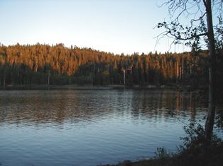
Beaver Meadow Reservoir
    
GPS-N.40.54.239-W.110.3.877 : Elevation-9,385 ft : 122 Acres : Depth Maximum-37 ft/Mean-17.7 ft
Travel south on HWY-43 from McKinnon, WY for 7 miles to the Wasatch National Forest. This road becomes FS-221. Continue south for 2 more miles and turn right onto FS-058 4.5 miles to the reservoir.
Big East Lake/Payson Lakes
GPS-N.39.56.137-W.111.38.436 : Elevation-7,870 ft : 23 acres : Depth Mean-29 ft
From I-15 in Payson take exit-154, and go south to US-6, then east on 6 for about .5 miles to the Nebo Loop Road. Where an old brick school is at the intersection. Travel on the Nebo Loop Road for about 10 miles up Payson Canyon to the Payson Lakes Campground and Big East Lake. Recreational facilities are well developed at the lake, and include lawns, flush toilets, and picnic areas. It is possible to get small boats on the lake, but motors are prohibited. The road is not plowed during the winter, but is groomed for snowmobiles and cross-country skiers. Fees are charged for camping, and with entrance gate is locked at 10:00 pm.
Boulger Lake
GPS-N.39.38.707-W.111.15.222 : Elevation-8,600 ft : 15 Acres
From Price, head northwest on US 6 up the canyon past Colton, and turn left onto UT 96. Drive around Scofield Reservoir, and turn right onto UT 264 to the lake.
Cleveland Reservoir
GPS-N.39.35.099-W.111.14.424 : Elevation-8,812 ft : 135 Acres : Depth Maximum-56 ft/Mean-33 ft
The lake is 19 miles east of Fairview and 29 miles northwest of Huntington. A sign on the highway identifies the lake. Snowmobiling is available in the winter. There are many places to launch a boat but noimproved boat ramps are available. There are no recreational facilities at the lake.
Currant Creek Reservoir
GPS-N.40.21.197-W.111.03.588 : Elevation-7,683 ft : 300 acres : Depth Maximum-123 ft/Mean-52.5 ft
40 miles east of Heber US-40 between Fruitland and Strawberry Reservoir the turnoff will be at milepost 59.3. There are large signs directing traffic to the turnoff at Current Creel Lodge. Travel up-canyon for about 10 miles on a gravel road to the reservoir. The Currant Creek Cafe, at the turnoff, has gas, food, fishing licenses, and other services. There are some great camping spots along the way to the reservoir, mainly for fishing. There are no services at the reservoir. There is a campground at the reservoir with tent sites, picnic areas, toilets, a boat ramp, and handicapped facilities. The Current Creek Nature Trail is only a 1.25 mile loop that begins near the campground. Turn left to Loop D and follow the road to Tot-Lot and park.
Duck Fork Reservoir

Elevation-9,305 ft : Surface area-46.9 acres : Depth Maximum-35 ft/Mean-17.5 ft
 
Duck Fork Reservoir is accessible on a dirt road from Ferron Reservoir. From Ferron, travel east past Millsite Reservoir, and continue on the gravel road as it ascends Ferron Canyon, enters a narrow side canyon and climbs to a high bench area. Ferron Reservoir is 25 miles west of Ferron City. From Mayfield, travel up the canyon, crossing the plateau on Skyline Drive at 10,500', and descend into Ferron Canyon. Ferron Reservoir is 23 miles east of Mayfield. From Ferron Reservoir, turn north, below the dam, and follow this road for 5 miles as it goes northeast and then west to the reservoir.
DMAD Reservoir
GPS-N.39.23.760-W.112.29.456 : Elevation-4,665 ft : 1,199 Acres : Depth Maximum-24 ft/Mean-9 ft
From Delta, head north on US 6 past the airport to a dirt road on the right. Access is several miles south of the airport on US-6. Access to the dam is from a dirt road at the south end of "the river dip"-the 1/2 mile stretch of US-6 that dips into the Sevier River Valley. This road to the reservoir is marked with a small wooden sign. The turnoff, at the south end of the river dip, is 4.5 miles northeast of Delta and 12 miles south west of Lynndyl. Access to the north shore of the reservoir is from several roads leaving US-6 several miles north of the river dip. The land that is now submerged by the reservoir was not cleared of trees and vegetation before flooding, making recreation somewhat hazardous and unappealing. Fish production is low.
Fairview Lakes
GPS-N.39.38.626-W.111.18.762 : Elevation-8,975 ft : 105 acres : Depth Maximum-40 ft/Mean-21 ft

From Fairview, travel 10 miles up U-31 to U-264. Turn east on U-264, follow it for about 2 miles and turn south on Skyline Drive at Beaver Dam Reservoir. Follow Skyline Drive for 1/2 mile, and turn south on a road for 1 mile to Fairview Lakes. From Huntington, follow U-31 for about 35 miles which is 3 miles north of Huntington Reservoir to Skyline Drive. Turn north and follow Skyline Drive for about 3 miles to a road, and turn south for one mile. U-31 is plowed throughout the winter, and this is one of the state's premier winter recreation areas for snowmobiling. Fishing and boating is the primary summer use of the lake. There is a private campground at the lake managed by the Fairview Lakes Association with campsites, a restaurant, and a gravel boat ramp. The lakes are stocked with rainbow trout.
Ferron Reservoir
Elevation-9,472 ft : Surface area-57 acres : Depth Maximum-30 ft/Mean-12 ft
From Ferron, travel west past Millsite Reservoir, and continue on the gravel road as it ascends Ferron Canyon, enters a narrow side canyon and climbs to a high bench area. Ferron Reservoir is 25 miles west of Ferron City. From Mayfield, travel up the canyon, crossing the plateau on Skyline Drive at 10,500', and descend into Ferron Canyon. Ferron Reservoir is 23 miles east of Mayfield. Snowmobiling is available in the winter. Boats can usually be launched on the reservoir. Ferron Canyon is maintained as a snowmobile route in the winter. Recreational facilities consist of a Forest Service Campground and a private resort, both are on the shoreline of the reservoir. Ferron Campground has 30 campsites with picnic tables, fire pits, privies, and drinking water. User fees are charged. Skyhaven Resort has cottage rentals, boat rentals, horse rentals, bicycle rentals, a convenience store, and a cafe.
Gooseberry Reservoir
GPS-N.39.42.997-W.111.17.594 : Elevation-8,424 ft : 77 Acres : Depth-Maximum-16.4 ft : Mean-3.7 ft
From Fairview, drive 10 miles east on U-31, and take highway U-264 near the top of the mountain. Shortly after leaving U- 31 as U-264 turns eastward towards Electric Lake, a gravel road will go north to the reservoir. Snowmobiling is available in the Winter.
Grassy Lake
9.35 Acres : N.39.19.283-W.111.19.800
From the west side of Joe�s Valley Reservoir take Forest Road 8 which turns into a dirt road. After about 3.5 miles turn right onto Forest Road 055, and continue another 2 miles to the lake. Stocked with brook, rainbow, & tiger trout.
Great Salt Lake

GPS-N.40.44.15-W.112.12.06 : Elevation-4,500 ft : 1,000,000 Acres
(South Shore) Take I-80 west to exit 104. Drive NW for 2 miles to the State Park and park by the locked gate. Then walk another mile NE to the lake.
(Antelope Island) From I-15 take exit 335, and go west for 7 miles, to the Antelope Island State Park fee booth. Theere is an entrance fee.
The water is 5x�s saltier than the ocean, being saltier in the north than the south. The lake is 75 miles long, 35 miles wide, and no more than 34 feet deep, making it the largest US lake west of the Mississippi River. The sulfurous smell is due to decaying algae and brine shrimp on the shore. The only fish in the lake are at the mouths of the rivers that dump into the lake. Once the fish hit the salt water they quickly die. The lake is mainly used for bird sanctuaries that nest over 200 bird species. Sailing, swimming, and kayaking are also a popular activity at the lake.
Huntington Reservoir
GPS-N.39.35.275-W.111.15.777 : Elevation-9014 ft : 118 acres

From Huntington take UT 31 northwest 32 miles, and the lake will be on your left. The lake is also 16 miles east of Fairview. Snowmobiling is available in the winter. There is a parking area near the dam on the east end of the reservoir with toilets.
Little Dell Reservoir
Elevation-5,798 ft
Drive up Drive up Parley�s Canyon on I-80 East and take exit-134 up East Canyon, and the reservoir will be N/E on your right after about 5 miles. There�s no swimming, bathing or washing within the lake, no dogs, picnicking limited to restricted areas, no operations of motorized boats, limited day-use only due to public water source. Great place for fishing, and there is a fee for day-use.
Long Park Reservoir
GPS-N.40.54.270-W.109.52.676 : Elevation-8,646 ft : 300 Acres : Depth-Maximum 96 ft : Mean-45.9 ft
14 miles west of U-44 from near milepost 15 on U-44, turn west on the Sheep Creek Geologic Loop. A sign reads "Long Park Reservoir 14". Follow the Sheep Creek Road for three miles, and then turn west on a gravel road also signed to Long Park Reservoir. This is the North Slope Road. Follow it for nine miles to the turnoff to Long Park Reservoir on the right. The lake is two miles north on this road. The water is crystal clear and is a great place for swimming. Boating is best in the spring before the water is drained down to the conservation pool.
Lost Creek Reservoir
GPS-N.41.11.079-W.111.24.022 : Elevation-6,000 ft : 355 Acres
From Parley�s Canyon Turn onto I-84 north of Echo Reservoir to Croydon exit. Follow UT 158 north on Croydon Road eventually turning into Lost Creel Road. Follow it for 10 miles until you reach the reservoir. There is fishing with very few visitors other than the widow maker climb that takes place annually. The last time I was here the campground was shut down.
Mary�s Lake
From the south end of Joe�s Valley Reservoir take Forest Road 041 for 7 miles to the lake. The lake is stocked with rainbow trout.
Mill Hollow Reservoir
GPS-N.40.29.477-W.111.06.236 : Elevation-8,843 ft : 18.50 Acres : Depth-Maximum-36 ft : Mean-18 ft
Head south east on U-35 for 14 miles, and turn south off U-35 onto an improved gravel road to Mill Hollow Reservoir. The reservoir is 3.5 miles south on this road. Swimming is available. There is a campground at the lake that offers fishing, a swimming area, drinking water, and privies.
Miller Flat Reservoir
GPS-N.39.32.655-W.111.14.630 : Elevation-8,462 ft : 158 acres : Depth Maximum-64 ft/Mean-39.9 ft

A gravel road located between Huntington and Cleveland reservoirs is the turnoff point from U-31. The road is well marked and Miller Flat Reservoir is approximately 3-4 miles south. This road continues past the reservoir and ends at Joes Valley Reservoir. Swimming, nordic skiing and snowmobiling.
Oowah Lake
N.38.30.085-W.109.16.419 : 2.46 Acres
Reached by Forest Road 076 from the south end of the loop road. There is USDA Forest Service camp sites available at the lake. The lake has rainbow and brook trout. There is also a hiking trail that takes you 1.7 miles to Warner Lake.
Pete�s Hole
8.70 Acres : GPS-N.39.17.586-W.111.23.229
This small lake is located between Skyline Drive and Joes Valley Reservoir. Drive up Forest Road 8 and is about .75 mile on Forest Road 055. This place offers some great fishing for rainbow trout. Soup Bowl is just around the corner also with planted rainbow trout.
Potter�s Pond 1 & 2
4 Acres each : GPS-N.39.26.981-W.111.16.182
Located between Miller Flat Reservoir and Joes Valley Reservoir about .5 mile off Forest Road 014. Take Forest Road 271 to the small ponds. These ponds are heavily stocked with rainbow trout.
Red Creek Reservoir
GPS-N.40.18.660-W.110.51.053 : Elevation-7,224 ft : 146 Acres : Depth Maximum-95 ft : Mean-40.1 ft
Red Creek Reservoir is easily accessible from US-40 in Fruitland. Turn north on the road across the street from the Fruitland store/gas station and continue for about seven miles. The road essentially terminates at the reservoir. There are no services at the reservoir, but gas and supplies are available in Fruitland. The area is entirely private land. You are a guest here, so pack out what you pack in.
Warner Lake
N.38.31.093-W.-109.16.447 : 3 Acres
This tiny lake just north of Oowah Lake has rainbow trout.
Willow Lake
N.39.08.166-W.111.23.229 : 15.13 Acres
From Ferron head west past Millsite Reservoir on Forest Road 022 (gravel road) for 15 miles up the canyon. The lake will be on the south side of the road. The lake has rainbow, brook, tiger trout, and grayling in it.
|

